10.8 km | 13.3 km-effort
manoir courbpyer
fournieralain
User
Length
12.8 km
Max alt
253 m
Uphill gradient
265 m
Km-Effort
16.4 km
Min alt
164 m
Downhill gradient
266 m
Boucle
Yes
Creation date :
2020-07-10 07:01:41.822
Updated on :
2020-07-10 12:37:29.809
4h29
Difficulty : Very easy
FREE GPS app for hiking
About
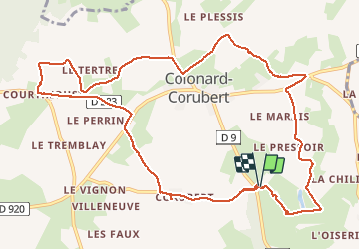
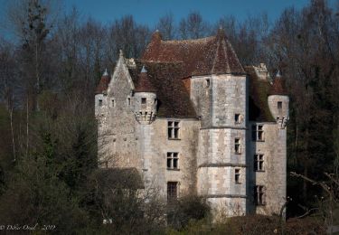
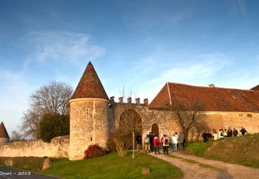
Trail Walking of 12.8 km to be discovered at Normandy, Orne, Perche en Nocé. This trail is proposed by fournieralain.
Description
boucle de 13kms
Positioning
Country:
France
Region :
Normandy
Department/Province :
Orne
Municipality :
Perche en Nocé
Location:
Nocé
Start:(Dec)
Start:(UTM)
327405 ; 5363139 (31U) N.
Comments
Trails nearby
SityTrail - La Maison du bois Nocé 11 Km
Walking
Difficult
Perche en Nocé,
Normandy,
Orne,
France
2h 49min
Yes
SityTrail - In Memoriam Saint-Jean-la-Forêt 5,9 Km
Walking
Medium
Perche en Nocé,
Normandy,
Orne,
France
5.9 km | 6.9 km-effort
1h 34min
Yes
SityTrail - St Aubin des Grois 13.66
Walking
Medium
Perche en Nocé,
Normandy,
Orne,
France
13.6 km | 16.2 km-effort
3h 33min
Yes
Nocé-Courboyer - Rémalard 14 km
Walking
Difficult
Perche en Nocé,
Normandy,
Orne,
France
14.4 km | 17.5 km-effort
6h 43min
No
Nocé-Courboyer - Saint-Aubin-des-Grois 9,5 km
Walking
Easy
Perche en Nocé,
Normandy,
Orne,
France
9.5 km | 11.2 km-effort
2h 25min
No
Les Trois Clochers 12 km
Walking
Medium
Perche en Nocé,
Normandy,
Orne,
France
12.2 km | 15.6 km-effort
10min
Yes
Le Vieux bourg 5km
Walking
Very easy
Perche en Nocé,
Normandy,
Orne,
France
4.8 km | 6.1 km-effort
1h 19min
Yes
Le Ruisseau du Merdereau 3,4 km
Walking
Very easy
Perche en Nocé,
Normandy,
Orne,
France
3.4 km | 4.2 km-effort
54min
Yes
Boissy-Maugis 8,4 km
Walking
Easy
Cour-Maugis sur Huisne,
Normandy,
Orne,
France
7.6 km | 9.5 km-effort
2h 13min
Yes